Tour du Mont Blanc
-
Val d’Aosta
Lorem ipsum dolor sit amet, consectetur adipiscing elit. Ut elit tellus, luctus nec ullamcorper mattis, pulvinar dapibus leo.
Gran Paradiso National Park
Day 1 – Colle del Nivolet and lakes tour
It’s the Aostan access to the Colle del Nivolet where you will find the Rifugio Savoia, built in 1860 as a royal hunting manor. From the parking in Port Valsavaranche, yellow signposts point to the start of the dirt path to the Colle del Nivolet. The pathway climbs in a forest of larches, passes a beautiful waterfall and becomes steeper and steeper until the panorama opens up onto the Gran Paradiso glacier. Few bends of the pathway will take you after 1 hour walk to the Arolley Cross (2310 m). Going on, you will walk the open plane of the Nivolet, a 6 km path surrounded by an open nature that reminded us of the Hobbit’s Shire. Walk along the river until you reach the Rifugio Savoia, on the shores of the Lake Nivolet.
Book in advance your bunkbed at the Rifugio Savoia for the night, you will need an early start on Day 2 for the Basei glacier. The Rifugio is not your typical mountain hut with warm people, it’s on the main road and its customers are mainly bikers, but it’s clean and will do for one night.
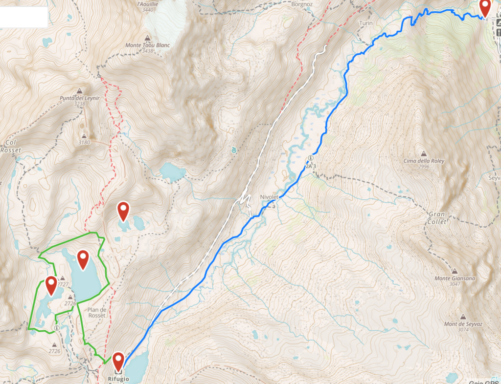
Spend the afternoon exploring the lakes behind the Rifugio. This lakes tour is a magnificent itinerary, not too tiring but instead with an awe-inspiring landscape. Once you have reached the peak of the Colle del Nivolet you have admired the two lakes of Nivolet in front of the Rifugio; now follow the right-side dirt path on the back of the Rifugio (yellow signs) which with a gentle slope will lead you to the plane from where you can explore the three lakes. If you keep walking straight ahead of you, you will reach the Lake Rosset, a transparent pearl that is overhung by the Punta Basei and its glacier. Continue your walk and leave the first lake on your left to reach the Lake Trebecchi, the best place to admire the Gran Paradiso that is reflecting in its waters. Go back towards the Lake Rosset, walk along its shores towards the Punta Basei and you will arrive at the Lake Leita. During your walk you will certainly encounter groundhogs that spy on you from behind the colored flowerbeds.
Day 2 – Punta Basei
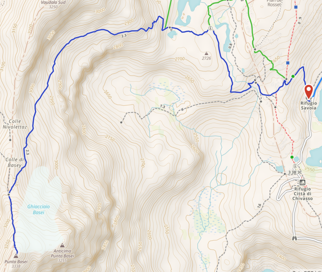
An amazing climb in a varied and colorful panorama. The trek is to be considered alpinist only in its final portion that requires some skills on ice and rock climbing, and some equipment (tampons and picks). The path starts behind the Rifugio Savoia and gently rises on a hill next to the Lake Leita (2700 m). At the left edge of the Lake Leita the path starts a steep climb to reach a crossroad where you will take the right path. After a section with lots of debris you will reach a plane from where you can admire the small Basei glacier (your goal) and the Lakes Nivolet below (your starting point). Keep following the path and you will reach the edge of the glacier. Here you can decide whether to continue left and cross the glacier to the peak, or walk towards the right side and the crest of the mountain where in the summer season the terrain is cleared of ice. In the second case, while ascending with the help of fixed metal ropes, you can admire on your right the Val di Rhemes. In few minutes you will reach the cross at the peak of the Basei (3338 m), on of the most panorami peaks of the Gran Paradiso National Park, with a 360 view on the Gran Paradiso, Cervino, Monte Rosa and Monte Bianco.
Day 3 – Aosta
Lorem ipsum dolor sit amet, consectetur adipiscing elit. Ut elit tellus, luctus nec ullamcorper mattis, pulvinar dapibus leo.
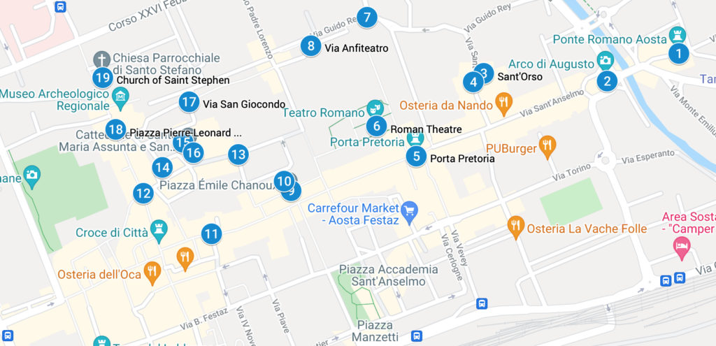
Our tour starts at at the Arch of Augustus (2), the entrance door to the Italian peninsula during the Romans times. It was built to celebrate the victory of Augustus emperor of the 25 BC. The pitched roof is from 1917 and the crucifix above from the XV century. Keep walking beyond the Arch and pass the river Buthier to admire an original Roman bridge (1). The street that now starts from the Arch is via Sant’Anselmo, the heir of the Roman decumanus that was the backbone of the city: keep walking along it and on the right (still outside of the original Roman walls) you will reach the Church of Sant’Orso (3), the most famous religious site of the city of Aosta and still a pilgrimage stop for those walking the Via Francigena.
Once you reach the Church, on your right side you will see the tickets stand for the cloister: while you’re queuing for the tickets, admire the three buildings and the octagonal tower that form the priory in which you are standing. It was built by Giorgio di Challant (the noble aostan family of the Middle Ages) in 1468. The tickets will allow you a visit to the cloister, surrounded by 52 capitelli built from 110 onwards, that tell the story of the life of Saint Orso. A written legend outside of the cloister gives detailed explanation to each capitello. To the left of the cloister, the Church of Saint Orso dates to the year 994: walk the three navels and admire the wooden choir and the glazed windows.
In front of the Church, stop to admire a 400 years old linden and follow the small road to the paleo-christian Church of San Lorenzo (4), now deconsecrated, that hosts in the basement a nice archeological tour of the original church remains and of the adjoined burial ground.
Back to Via Sant’Anselmo you will reach the Pretorian Doorway (5), the true monumental entrance to the Roman city. Enter through one f the three arches and you can still feel the grandiosity of the Roman Empire. Once you are inside the Roman walls, on your right you will be able to admire the Roman Theatre (6) that during the I century BC could host an audience of 3000 people. Its grandiosity had the scope to leave in awe whoever was entering the Roman Empire from Gaul.
Keep walking to Torre dei Balivi (7), the residence of the Savoia representative in the city during the 1200, and turning left you will see the remains of the amphitheater (8) of the I century DC. Another left turn will take you to Piazza Chanoux (9), the heart of the city, built under the rein of Carlo Alberto of Savoia. This huge piazza is the heart of the modern Aosta, where ceremonies, expositions and markets are held. The Hotel de Ville (10) occupies nearly 140 meters of the right side of the piazza. The neoclassical facade is characterized by porches. Being a public office, you may be just able to glimpse the staircase and the ample salon.
Exit the piazza by via Jean-Baptiste de Tillier (11), continue to via Croix de Ville (12) and via Monsignor de Salles (13) to admire the neo-classic buildings, and remember that Calvin flew Aosta from these streets once he failed to convert the city. You will reach piazza Giovanni XXIII (14) that act as a stage for the criptoportico forense (15) and the Cathedral (16).
On the left side of the piazza, by a staircase, you will gain access to the monumental gallery that forms the criptoportico (a hidden porch, basically), that has an horse-shoe plant and had the initial scope of an indoor walk. Between the III and IV century, it became a storage area. When we visited Aosta, the Cathedral (16) was closed but maybe you will have better luck.
Continue your visit to via San Giocondo (17), that used to be the religious part of the city, and reach piazza Roncas (18)that used to be the cardo maximus through which Romans could reach the passo del Gran San Bernardo. On one corner of the piazza you can admire an hidraulic wheel that works over a small channel of Roman origins.
Last stop of our itinerary is the Church of Saint Stephen (19), now outside of the Roman walls, that has a massive wooden statue of San Cristoforo inside.
Monte Bianco
Day 4- Val Veny “Balcony”
Equivalent to anti-clockwise stage 4 in Kev Reynolds’ TMB (Tour Mont Blanc) guidebook. This stage can be walked independently, not as part of the whole 10 day trek. Features a moderate 600m/600m elevation gain/loss, and spectacular and continuous views of the Italian side of the Mont Blanc (Monte Bianco). Total walking time of the full day hike as marked: 5-6 hours excluding optional detours (Lago Miage and Rifugio Elisabetta). Generally recommended from June to September, but check weather forecast and avoid in bad weather.
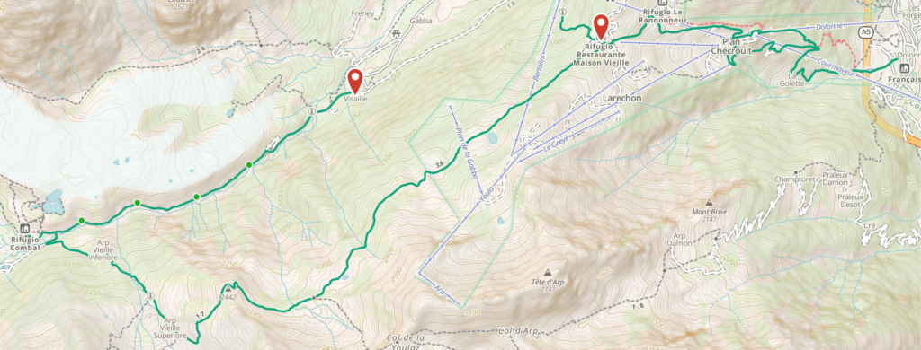
Get to La Visaille (1800m) at the top of the Val Veny valley road. Either drive all the way up and park between the bridge and the closed gate, or take the hourly Val Veny bus from Courmayeur to the last stop.
Walk up the valley for about an hour (ascending about 200m), and connect to the main TMB trail near Combal (2000m). Optional 30 min detour to Lago Miage (recommended).
Ascend along the TMB for about an hour to the highest point of the trail (2400m), then descend to Rifugio Maison Vieille (2000m).
From Rifugio Maison Vieille you have several options:
a. Easiest: Descend to Courmayeur (1300m) using the Dolonne cable car in July-August only: http://www.courmayeur-montblanc.com/?
b. Longest: Descend to Courmayeur (1300m) on foot, following the main TMB trail
c. Shortest: Descend straight to Val Veny valley (1700m), where the aforementioned bus has multiple stops along the valley road.
d. Closing the loop: Descend back to La Visaille (1800m), where your car is parked – this route is marked on the map.
For options C and D – take trail number 6 which goes north-west from the Rifugio clearing.Day 5 – Dent du Geant and Aiguille du Midi